http://mt.rainier.tribnet.com/geology/geo3.asp

The Highest Lake in the United States of America
http://www.highestlake.com/highest-lake-usa.html
(C)Copyright 2002 by Carl Drews
Last update: January 10, 2004
Unofficial lake names (not recognized by the USGS) are in "quotes".
Contents:
| Rank | Name | Feet | State |
| 1 | "Lake Muriel" | 14,100 | Washington |
| 2 | Pacific Tarn | 13,420 | Colorado |
| 3 | "Rowe Lake" | 13,100 | Colorado |
| 4 | "Windom Lake" | 13,100 | Colorado |
| 5 | Winchell Lakes | 13,100 | Colorado |
| 6 | "Harriet's Pool" | 13,100 | Colorado |
| 7 | Lake Waiau | 13,020 | Hawaii |
| 8 | North Halfmoon Lakes | 13,020 | Colorado |
| 9 | Frozen Lake | 12,950 | Colorado |
| 10 | Ptarmigan Lake | 12,939 | Colorado |
| 11 | Sloan Lake | 12,920 | Colorado |
| 12 | "Caltech Lake" | 12,890 | California |
| 13 | Summit Lake | 12,830 | Colorado |
| 14 | Tulainyo Lake | 12,802 | California |
Lake Muriel is a subterranean lake heated by fumarole vents within the summit crater of Mt. Rainier. I don't really think this one qualifies as a lake. It's just way too small. There are also some comments indicating that this pool of meltwater is a temporary feature. But it is very cool!
Here is an article about exploring the summit fumarole caves of Mt. Rainier. There is a "lake" that explorer Bill Lokey named "Muriel" after his mother. The crescent-shaped pool of glacial meltwater looks pretty small, but it is 20 feet deep. Other explorers are Fran�ois Le Guern and Emmanuel Ponzevera. Good pictures! In the early 1970s, the National Geographic Society sponsored one of the first expeditions (Project Crater) to systematically explore and study the subterranean maze. The date of this article is 1998 (� 2002 Tacoma News Inc.).
http://mt.rainier.tribnet.com/geology/geo3.asp
That sounds like a lot of work to carry a rubber raft up to the summit crater of Mt. Rainier! I've hauled a big video camera to the summit of Longs Peak, and lugged a wet sleeping bag and tent over the top of Kilimanjaro. But I think these guys have outdone me on the "grunt score".
See also this story of a mountain rescue involving HACE (High Altitude Cerebral Edema), reported by Sandi Doughton:
http://mt.rainier.tribnet.com/recreation/rec11a.asp
This report of that same mountain rescue incident asserts that the summit lake is 50 x 30 feet in size (reported by Maria Level & Roger Ternes). That's about .034 acres. Pretty small!
http://www.tacoma.washington.edu/css/tmru/Missions/Mission8_13_98.html
These stories indicate that Lake Muriel is 150-300 feet below the surface. The "surface" is probably the bottom of the two summit craters, which are flat areas enclosed by the low rock walls of the crater rims. The summit elevation of Mt. Rainier is 14,410 feet. I climbed it in 1985. Lacking more accurate information, I have estimated the elevation of the lake surface to be about 14,100 feet.
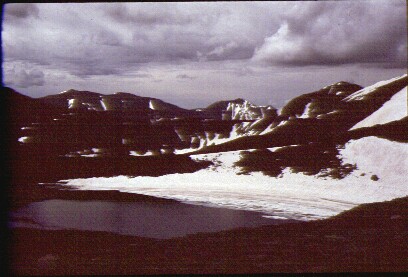
This peaceful sheet of liquid glass lies perched, catlike, on the very spine of our nation. I first became aware of Pacific Tarn through an article in the Colorado Mountain Club's newsletter Trail and Timberline, sometime in the mid-to-late 1980s. The article had a black-and-white photograph of Pacific Peak (13,950 feet) southwest of Breckenridge in the Tenmile Range, showing a large tarn below the peak. A tarn is a high mountain lake that forms in a glacial cirque. The article speculated that the unnamed tarn was perhaps the highest lake in the country.
In August 1993 I led a backpacking trip from my church's youth group to the Tenmile Range west of Breckenridge. We camped at about treeline and climbed Pacific Peak the next day. I took a picture of the lake. Even though the lake had no name on my topo map, I started calling it "Pacific Tarn" in my mind. Simple. Descriptive.
Special thanks to Michael Drews for scanning in my slide.
Fast-forward to spring 2002. I was surfing on the Internet during a long compile, looking at photos of the summit areas of Mauna Kea and Mauna Loa on the Big Island of Hawaii. I found a few pictures of a little lake called Lake Waiau near the summit of Mauna Kea. Neat-oh! The text accompanying these pictures asserted that Lake Waiau was the third-highest lake in the United States, leaving me to wonder what were lakes #1 and #2?
Surely they could not be referring to Lake Muriel and Pacific Tarn? I had heard rumors of a subterranean crater lake on Mt. Rainier from my brother Michael, and after some searching on the Internet I found Lake Muriel. A little more surfing, and some inquiries, revealed that Lake Waiau was supposed to be the highest lake in the United States, and the third highest lake in the world. This still left the question of what were world lakes #1 and #2, but I was confident that I could tease that information out of the search engine Google somehow.
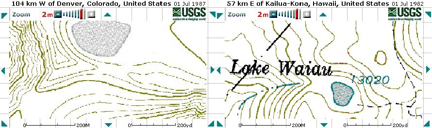
I work writing software with an interesting guy named Paul Fearing. Paul has done snow modeling with higher mathematics to simulate realistic snowfall pictures, so he knows mountains and bodies of water. He's also hiked a lot in British Columbia and Colorado. I mentioned my "Pacific Tarn" question to him, and it instantly captured his attention! We checked out the topographical maps, and sure enough, Pacific Tarn looked higher and bigger than Lake Waiau. Pacific Tarn is also bigger than a couple of named Colorado lakes nearby. Click on the link below to see a digital map showing Pacific Tarn:
http://terraserver.homeadvisor.msn.com/image.asp?S=11&T=2&X=1009&Y=10909&Z=13&W=0
Scroll north from there, or click on the link below to see a sliver of the lake with Pacific Peak:
http://terraserver.homeadvisor.msn.com/image.asp?S=11&T=2&X=1009&Y=10910&Z=13&W=0
At this point I wrote to the United States Geological Survey (USGS), asking for their list of the highest lakes in the country, and perhaps an official definition what is a "lake"? They kindly wrote back to say that they maintain a database of all named geographical features in the country. Your tax dollars at work! You can search the database for Feature Name = lake at this way cool web site below. Be sure to set an elevation range of 12000-24000 feet or so, otherwise you'll get every lake in the country.
http://geonames.usgs.gov/pls/gnis/web_query.gnis_web_query_form
They don't have an official definition of what constitutes a "lake". A body of water doesn't have to be called a "lake" for it to be official; there is a Leavick Tarn listed in the USGS database under Lakes in Colorado. Of course "Pacific Tarn" wasn't on the list because that was my personal name, but there was no lake listed in the right place and elevation. My topo map showed no name either, and the USGS database lists only named features. Bummer.
I took digital maps of Lake Waiau and Pacific Tarn, and pasted them together at the same scale below. As you can plainly see, Pacific Tarn is bigger. I estimate that the surface area of Pacific Tarn is 5 acres, and Lake Waiau covers 2 acres.
Paul Fearing is a trip leader in the Colorado Hiking And Outdoor Society (CHAOS). He's always looking for interesting and non-14er places to go backpacking. We quickly hit upon the most excellent idea of taking an expedition to the lake; to measure it, take pictures, and bring back some scientific evidence to back up our theory that Pacific Tarn is the highest lake in the country. If we could verify the lake and measure it accurately, perhaps the USGS would add it to their database. Another friend at work, Paul Riciputi, enthusiastically volunteered to find a rubber raft so we could go boating on the lake and sound its depth. Great!
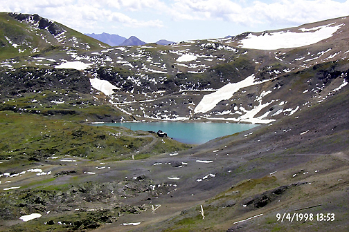
We are planning The Great Pacific Tarn Scientific Expedition for July 2002. We hope to take lots of photos, measure the depth of the lake, and record the pH and temperature for good measure. Real scientists measure stuff like that! We are somewhat worried about what we might find, because the spring of 2002 in Colorado has been the driest spring in recorded history! If the lake has dried up or drastically lowered, we will record the actual depth and try to estimate the usual depth from the historic shoreline. Pacific Tarn might be a good indicator of global warming and climate change in the years to come.
Hiking in Colorado - Pacific Peak, by Steve Fry:
http://hikingincolorado.org/pacif.html
Pacific Peak, by Steve Johnson:
http://www.geocities.com/tepitw/pacificPk/pacificPk.htm
Here is another excellent trip report and photo of Pacific Tarn and Quandary Peak by Chris Wetherill. His picture was taken on September 29, 1991 and shows very little snow around the lake.
http://mtns.martianbachelor.com/Pacific.html

One important question, of course, is what to name this "new" lake? It has to have a good name worthy of its exalted place. So Paul and I sat down together and came up with what we thought was a pretty good list of possible names:
Unfortunately, we suspected that perhaps the good folks at the USGS wouldn't go for a couple of these names. Furthermore, I remember reading somewhere that the USGS does not permit geographical places to be named after living individuals. Although we might kill ourselves hauling a 3-man rubber raft up to Pacific Peak this summer, we are not willing to commit suicide just so that "our" lake will be named after us. We're crazy, but not that crazy. And I've got a wife and kids at home. So until we come up with a better suggestion, "Pacific Tarn" it shall be.
Here is the USGS web page that describes the guidelines for proposing a new geographic name. Plow through that if you dare!
http://mapping.usgs.gov/www/gnis/pppdgn.html
I'll be the first to admit that Pacific Tarn cannot compete with Lake Waiau in terms of history, familiarity, and ancient legend. But Pacific Tarn is bigger and higher than Lake Waiau! Does it not deserve also to be called a lake? Consider this letter from Outraged Reader Liam Griffith, in response to my clarion call for due recognition of Pacific Tarn:
Subject: Your battle cry heard loud and clear, Cap'n!
Commander!
Lead us On, Unserer Alles Fuhrer! We, who like you, take more umbrage than is called for by the slighting of Pacific Tarn say, with one voice, "Consider our Lives Forfeit in the Service of Your Pacific Tarn-ish Clarion Call for Justice and Rectitude." May we not draw breath again unless it be in absolute abandon to the service you call us to, oh tarn vetter.
My life, my fortune, my sacred honor! All for the Tarn!
Liam Griffith
Okay, I'll admit that Liam has been my friend for 15 years and that I provoked him into writing this letter. The point is that there are strong feelings over this matter! The citizens of Colorado and Breckenridge will not be denied our rightful place in the hallowed annals of geography! Many pints of beer are being wagered over this question even as we speak! So - to the USGS and the U.S. Board on Geographic Names we ask: Won't you please please please add Pacific Tarn to your database?
News Flash! On July 13-14, 2002 we completed our Great Scientific Expedition to Pacific Tarn, and it was a huge success! You can read all about what we found in this Trip Report.
News Flash! On January 8, 2004 the United States Board on Geographic Names formally approved my proposal to name the lake "Pacific Tarn"! This action means that Pacific Tarn is now recognized by the United States Geological Survey, and officially becomes the highest lake in the country. Yee-hah!!!
"Rowe Lake" is the unofficial name for the tarn below Rowe Glacier in Rocky Mountain National Park, between Rowe Peak and Hagues Peak (13,560 feet) in the Mummy Range. "Rowe Glacier Lake" might be another reasonable name, since the tarn is inextricably associated with the glacier, and the glacier is named.
Rowe Lake shows up on topo maps, despite the fact that it's frozen over for much of the year. I calculate its size from the map at about 125 yards wide by 200 yards long, a rough oval with a total surface area of approximately 4 acres. Michael Dallin has an interesting picture of Rowe Glacier here that shows the lake:
http://estes.on-line.com/rmnp/pics/html/md-rowe.html

Mike took that picture on July 17th, 1995, and as you can see there's only a small blue portion of the lake that is liquid water. 1995 was one of the snowiest and wettest years on record in Colorado, and Rowe Lake had a hard time that year melting through its wintry cloak.
Here are a couple of other web sites that show Rowe Glacier and Rowe Lake.
http://www.wildgardenproductions.com/rowegl.html
http://rockyweb.cr.usgs.gov/rmnp/hallet_name.html
"Windom Lake" is the rocky lake at the top of Grizzly Gulch just east of Windom Peak, between Silverton and Durango in the San Juan Mountains. (This is not the familiar lake at the top of Chicago Basin between Sunlight and Eolus.) I climbed Windom in a snow-pellet and lightning storm, so I didn't stop to admire the view. But there it is on the quad map, unnamed but marked at 13,100 feet. Has anyone ever visited this lake? Send me a picture if you've got one.
Here is a photo of "Windom Lake", taken by Tim Briese on July 31, 1999:
http://colomtnclimb.freehosting.net/chicagop12.htm
Here is another photo by Tim Briese showing the two lower lakes in Grizzly Gulch (one at 12,235 feet):
http://colomtnclimb.freehosting.net/chicagop8.htm
From the map Windom Lake appears to have an island. Josh Calder identified this as the highest island in the United States in the early 1990s. I wonder if anyone's ever waded out to it? Perhaps the highest island in the country has yet to be bagged . . . !
http://www.topozone.com/map.asp?z=13&n=4166762&e=271290&s=25
There is also a little splat of a pond on the standard route up Mt. Eolus. This pond shows up on the topo map at about 13,380 feet. Probably many climbers have filled up their water bottles in this pond before heading out across the famed "Sidewalk in the Sky." The pond is east of North Eolus and south of Glacier Point. It's about 50 yards across, for an area of 0.4 acres. That's too small to be called a lake. Sorry.
The east face of Blanca Peak in the Sangre de Cristo range has three lakes, labeled on the topo map as Winchell Lakes. The two lower lakes are of a respectable size, and their elevations are 12,400 and 12,800 feet. The label is positioned to suggest that the name applies only to the lower pair, but I can't be sure. The upper lake is smaller, and its elevation appears to be about 13,100 feet. The uppermost Winchell Lake is about 80 yards wide by 140 yards long, for a surface area of about 2.3 acres. That's just under the 1-hectare (2.471-acre) European guideline.
Here is a Blanca Peak trip report at sangres.com with lots of pictures. The image below shows the two lower Winchell Lakes.
http://sangres.com/mountains/blancapeak.htm

We have the same situation on the west side of Mt. Massive. The uppermost North Halfmoon Lake is at about 13,020 feet:
http://www.topozone.com/map.asp?z=13&n=4338462&e=371012
"Harriet's Pool" is a small lake in the cirque of Mts. Lincoln, Bross, and Cameron Point, in a valley known as Cameron Amphitheatre. James Graebner sent me this one, and he calls it "Harriet's Pool" after his grandmother. James reports that there are brown trout in the lake, which makes Harriet's Pool the highest lake known to have fish (sorry, I haven't really checked out the others). The pool is a parallelogram about 90 meters by 70 meters.
http://topozone.com/map.asp?z=13&n=4355765&e=404421&size=s&datum=nad83&layer=DRG25Harriet's Pool is also the highest lake accessible by jeep (you might be able to get to Rowe Lake by jeep, but there is no road and it would be illegal). I hope the jeep access and the fish are not related - don't introduce fish into these high lakes!
Lake Waiau is on the Big Island of Hawaii, near the summit telescopes of Mauna Kea. The ancient Hawaiians believed that spirits traveled to and from the spirit world through Lake Waiau, which had no bottom. Obviously the ancient Hawaiians never were crazy enough to pack a rubber raft all the way up to 13,000 feet, because the lake has been measured in modern times at 10 feet deep! The lake freezes over in winter. Scientists have found some extreme bacteria in the organic mud along the shoreline:
http://www.lpi.usra.edu/meetings/earlymars/pdf/3060.pdf
Click on the link below to see a topographical map showing Lake Waiau. You can zoom back to see Mauna Kea:
http://terraserver.homeadvisor.msn.com/image.asp?S=11&T=2&X=601&Y=5481&Z=5&W=0
Lake Waiau, by Rob Pacheco - "The View from Poliahu" (Copyright � 2002, Hawaii Forest & Trail, Ltd.):
http://www.hawaii-forest.com/essays/9906.html

Airphotos of Mauna Kea Volcano, Copyright by P. Mouginis-Mark:
http://satftp.soest.hawaii.edu/space/hawaii/nav/ap.mauna_kea.html
Ian Richardson's Hawaiian Web Page; Lake Waiau:
http://www.angelfire.com/art2/ianr900/hawaii/waiau_0114.html
Now don't get me wrong. I love Hawaii! My wife and I had a fabulous time on our honeymoon there! The beaches are fantastic! The people are friendly, beautiful, and smart! The volcanos are fascinating! The surf is great! Volcano House at Kilauea even has the longest-burning fireplace in the world! We got mobbed by tropical fish while snorkeling at the Captain Cook memorial on Kealakekua Bay! I can pronounce humuhumunukunukuapua'a! Wow!!!
I just don't think they have the highest lake.
The North Halfmoon Lakes are on the west side of Mt. Massive near Leadville. It appears that the highest lake in the chain is not actually named, according to the placement of the label on the topo map.
http://www.topozone.com/map.asp?z=13&n=4338488&e=370972&s=25
Frozen Lake on the south face of Mt. Bierstadt is at about 12,950 feet (from the topo map). This lake is listed in the USGS database without an elevation.
http://www.topozone.com/map.asp?z=13&n=4380850&e=442697&s=25
http://sepwww.stanford.edu/sep/morgan/images/scenery/colorado/bierstadt/html/mb05_south_from_shoulder.html
http://www.geocities.com/Yosemite/Falls/7358/frcont02.htm
http://www.q-adventure.net/bierstadt/frozenlk2.jpg
There are 5 Ptarmigan Lakes in Colorado; the highest one is between Ouray and Telluride near Imogene Pass. I haven't been over Imogene Pass, but it's a relatively well-traveled 4WD road. For extreme athletes, there is an annual Imogene Pass Run over the pass between Ouray and Telluride.
Here is a trip report of a four-wheel-drive excursion over Imogene Pass that contains pictures of Ptarmigan Lake. The authors are Ed Beshore and Amy Phillips:
http://abell.as.arizona.edu/~hill/4x4/sjuan99/imogene.html
Sloan Lake is on the southwest side of Handies Peak near Lake City in the San Juan Mountains, on the standard hiker's route up through American Basin. Sloan Lake is listed in the USGS database without an elevation. I found its elevation and size of 5.7 acres on this list of high lakes published by the Colorado Water Conservation Board in the report "Natural Lake Tabulation - Water Division 4".
http://cwcb.state.co.us/isf/Downloads/div4lake.pdf
Here is information on the American Basin Trail at the BLM Colorado Gunnison Field Office. There is a nice picture of Sloan Lake by Arden Anderson.
http://www.co.blm.gov/gra/gra-american.htm
The link below is a fishing web site that describes Sloan Lake, from the web page Lake City Area Fishing Guide - Mountain Lakes.
http://www.geocities.com/Yosemite/Gorge/8209/Mountain_Lakes.html
"Caltech Lake" is my designation for the small unnamed lake on the northeast face of Caltech Peak, near Mt. Stanford. If this is a lake, then it's the highest lake in California. I'm reading the elevation off the topo map: 3,930 meters, or one contour line higher than Tulainyo Lake.
http://www.topozone.com/map.asp?z=11&n=4061419&e=376122&s=25
Jere Vandewalle had his eye on Caltech Lake for some time before I noticed it, knowing that the feature is higher than Tulainyo Lake and wondering if it qualifies as a lake. Jere also re-acquainted me with a little pond on the east side of Mt. Williamson at about 13,040 feet:
http://www.topozone.com/map.asp?z=11&n=4057269&e=383779&s=25
I had noticed "Williamson Pool" during my map survey of the Sierras in the fall of 2002, but had decided not to list it because it's too small. Williamson Pool is about 300 feet long by 120 feet wide. As of August 2003 Jere is thinking about visiting the site to see if the pond is still there. Hurry up before the snow flies!
Summit Lake is on the north side of Mt. Evans, along the road that leads almost to the summit of Mt. Evans. This is the highest paved road in the United States (the highest paved continuous road is Trail Ridge Road in Rocky Mountain National Park). Mt. Evans is a great bicycle adventure if you start from Echo Lake, or especially from Idaho Springs(!).
Here are some nice photographs of Summit Lake, Copyright 1999 by Karl Snyder:
http://www.mountevans.com/ME-AreasSummitLake.HTML

There is also a tiny little pond at 13,300 feet on the north face of Mt. Evans above Summit Lake:
http://www.topozone.com/map.asp?z=13&n=4382419&e=444642&s=25
Summit Lake drains calmly out the east side and down the eastern slopes of the Evans Massif through Bear Creek. However, there is a low rocky sill on the north side of the lake about 10 feet high, and then the valley plunges down steeply after that. If those rocks developed a crack from freezing and thawing, possibly Summit Lake could radically change the direction of its outflow and empty northward into Chicago Lakes and Chicago Creek instead. The drainage pattern of Summit Lake hangs by a thread! Mighty rivers teeter on the brink of drought or flood! Well, I think this is interesting even if no one else does. And this is my web page. So there!
"Ain't never been there, they tell me it's nice." - Joe Walsh.
Tulainyo Lake is a large and beautiful lake nestled in a curve of the Sierra Crest, just a few peaks north of Mt. Whitney. It is bigger by far than any of the other lakes on this list. Several people from the Ocean Swims group have been swimming in Tulainyo Lake:
http://www.oceanswims.com/YADA/yadayadayada.html

Isn't that just the way coolest thing you've ever seen? Here are some more pictures of Tulainyo Lake at PhotoTripUSA (Copyright 1998-2002 by Graphie International, Inc.):
http://www.phototripusa.com/e_gallery_1098.html
Tulainyo Lake, by Charles Foster and Somewhere Out There, Climbing Mt. Russell:
http://www.flash.net/~cfoster2/climbing/alpine/ca14ers/mtRussell/
Here is a dive report in Adventure Sports Journal, by Peter Hemming. These guys hauled scuba equipment up to Tulainyo Lake for a little dip! That's impressive.
http://www.adventuresportsjournal.com/OtherSports/tr20010713b.shtml
Here is the same report but with more pictures:
http://www.peterhemming.com/Journ.html
We really need someone to measure the depth of Tulainyo Lake accurately. Come on - how hard can it be to haul a rubber raft, two paddles, and a portable sonar unit up to 13,000 feet? Surely there must be a few Californians crazy enough to do it! I will publish your results here.
Iceberg Lake near Mt. Whitney does not seem to be listed in the USGS database, although it is named on topo maps and familiar to climbers. Iceberg Lake is at 12,600 feet. The database does list another Iceberg Lake near Mt. Ritter in Madera County.
Colorado, California, Utah, Wyoming, and Alaska have a lot of terrain above 13,000 feet. It's possible that there is another unnamed high lake lurking out there, just waiting to be discovered . . . !
There is a little pond at 13,300 feet just south of Clinton Peak in Colorado that shows up on the topo map. This is east of Climax (Fremont Pass). That's too small, but thanks for trying.
My friend Nils LaVine remembers a pool of meltwater that we saw while climbing Castle Peak in Colorado's Elk Range. It was directly north of the summit, in a high snow-filled cirque on top of the snow and ice. Does an official lake have to have a rock or mud bottom? Nils thought we might slip while ascending the snow slope to the west, and so he wants to name the pool "I Sure Hope I Don't Fall Into The Lake Lake," which I think is a mighty fine name! I looked up this feature on my topo map, and by amazing coincidence it is also at 13,400 feet! The map even has those little line segments pointing toward the center of the contour circle, indicating that there is indeed a depression there. Unfortunately for I Sure Hope I Don't Fall Into The Lake Lake, the pool of meltwater was too small to be called a lake. I think it's a temporary feature, since the topo map doesn't show water there. Probably the layer of ice under the water seals the pool there, and the whole thing drains out through the rocks later in the summer. Sigh . . .
But that's just the kind of interesting feature we're looking for!